This page provides a general overview of the district's history.
There are companion pages on:
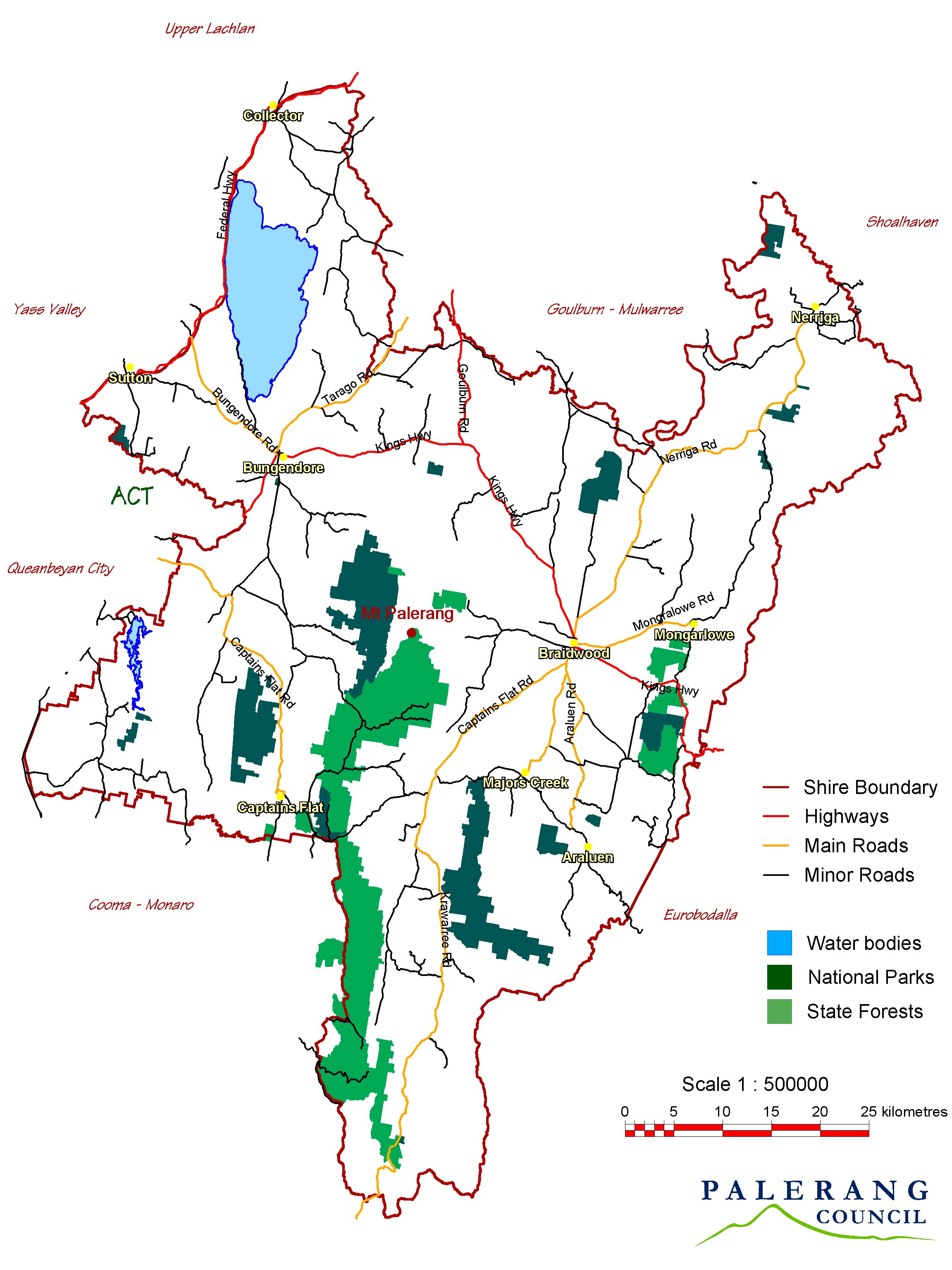
Here are Palerang Council's:
The relevant contour maps are:
- 1:100,000 Araluen
- 1:25,000 Kain
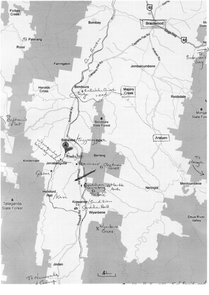
Click on the adjacent map for a larger version:
This is a page within Roger and Linda's
Bunhybee Grasslands Web-Site.
Bunhybee Grasslands is a 49ha/120-acre conservation property 35km south of Braidwood,
in sthn N.S.W.
You can follow through the internal links, or you may find it easier to use
the Site-Map.
This page provides a general overview of the district's history. There are companion pages on: Here are Palerang Council's: The relevant contour maps are:
Click on the adjacent map for a larger version: |
|
According to this web-page, the region around Braidwood was the traditional land of two aboriginal peoples - the Walbanga and the Wandandian - whose boundaries met near the junction of the Shoalhaven and Mongarlowe Rivers. This government web-page says that the locals were the Walbunja tribe of the Yuin Aboriginal people, also known as Dhurga, Djiringanj, Dyirringan. Those in the Bunhybee area may have been the Dyiringanj or Djiringanj. A combination of smallpox, tribal battles and the spread of venereal disease is said to have reduced their numbers from 11,000 to 600 between 1800 and 1850.
The ABC Indigenous Language Map suggests that Yuin dialects once dominated the South Coast of N.S.W. A Palerang Council web-page identifies the local dialect as having been Dhurga.
The district would have been rich enough to be attractive to hunter and gatherers, and the large numbers of apparently-Aboriginal place-names suggest that there was plenty of interaction between indigenous people and the early settlers.
The Wikipedia entry and a page on the Visit Braidwood site both say that European explorers by the name of Kearns, Marsh and Packer reached the Braidwood district in 1822. They had been involved in Charles Throsby's explorations of the Southern Highlands, which had led as far as Lake George, the ‘Limestone Plains’ (where Canberra was later established) and the Murrumbidgee River. It appears that they were sent onwards to investigate the possibility of a track between the Limestone Plains and Batemans Bay.
The area very quickly attracted settlers. This government web-page says that the first land grant in the region was made in 1825, to prominent Sydney surgeon Dr Thomas Braidwood Wilson (1792–1843), who called his property Braidwood farm (possibly his mother's maiden name?). The name was later changed to Mona. It lies 1km east of Braidwood, on the King's Highway towards Bateman's Bay.
The area to the south of Braidwood was also quickly claimed, with a property subsequently called Elrington granted to the magistrate, Major William Sandys Elrington, in 1827. According to Major's Creek's history page, that area was also settled by Elrington, who received a free grant there, also in 1827, of 2650 acres. Elrington also acquired land further south at Araluen.
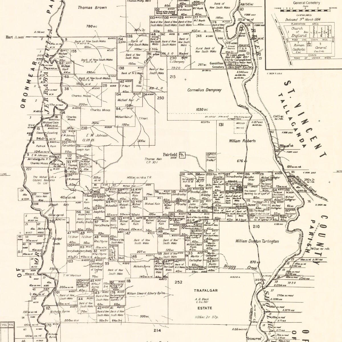
The first of the following map-segments shows Bunhybee and the surrounding blocks within 4km north, 3km east, 1km west and 6km south. The second and third maps show the blocks down to about 20km south of Bunhybee, between the Jerrabattgulla Creek on the west and the Shoalhaven on the east.
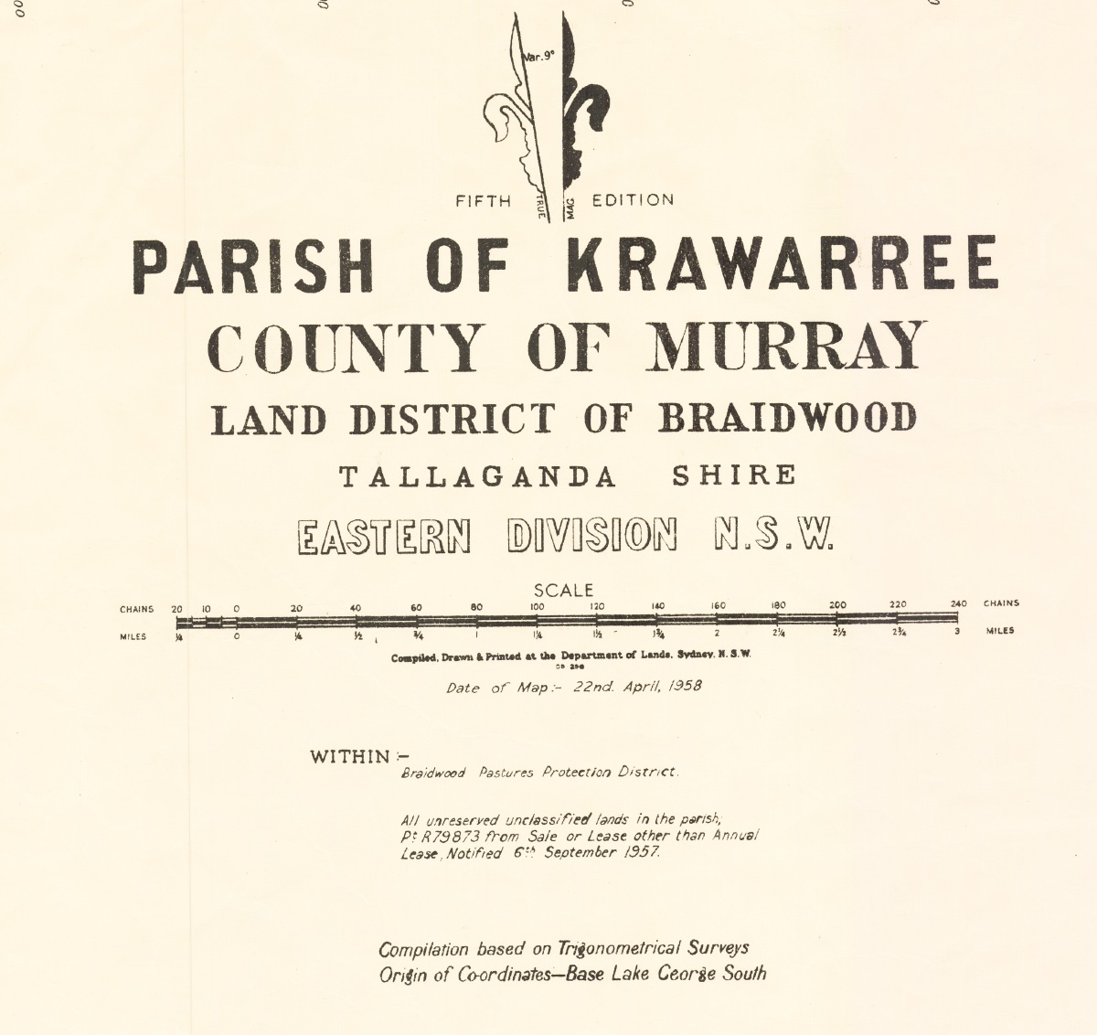
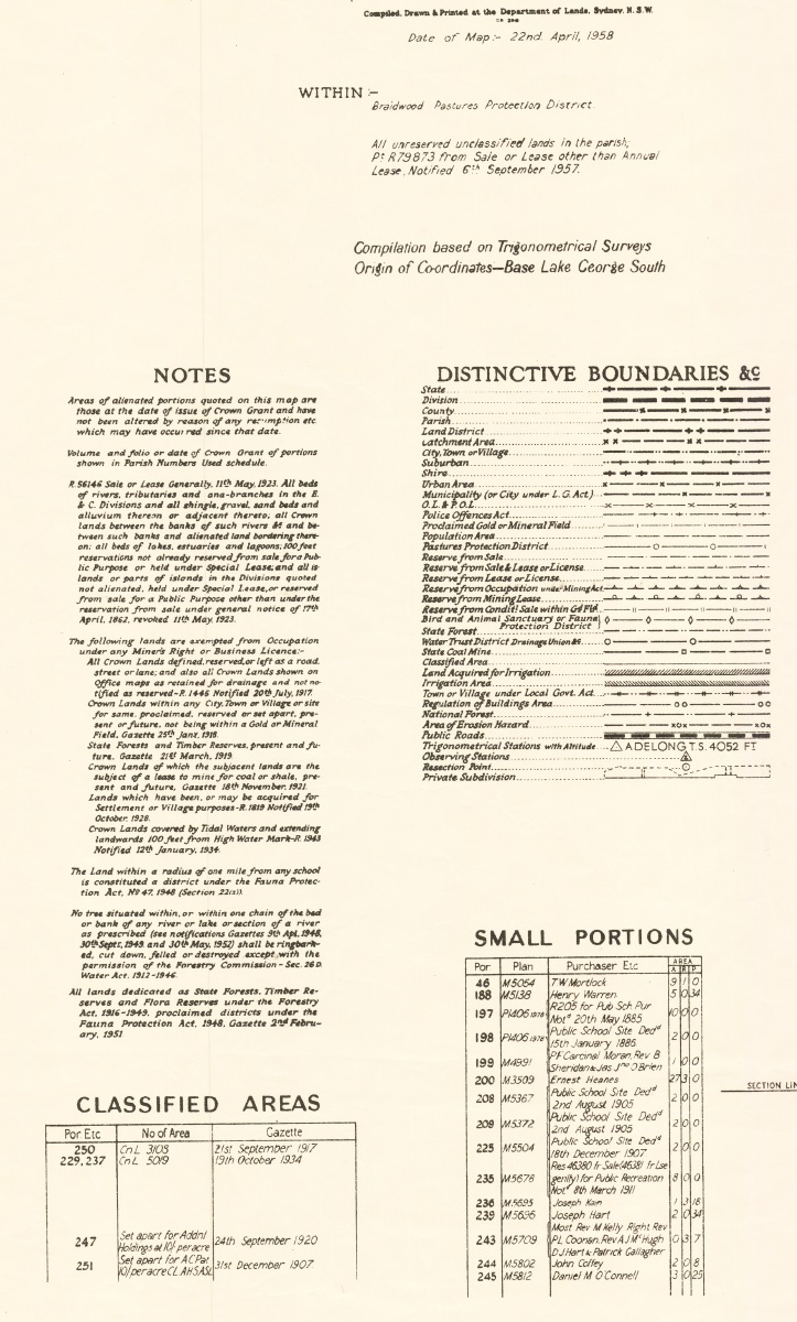
Cadastral (Property-Boundary) Map of the
Parish 5th Edition, printed in 1958, showing [original?] land-owners' names (Source: NSW Dept of Lands, copy from the National Library) |
 |
 |
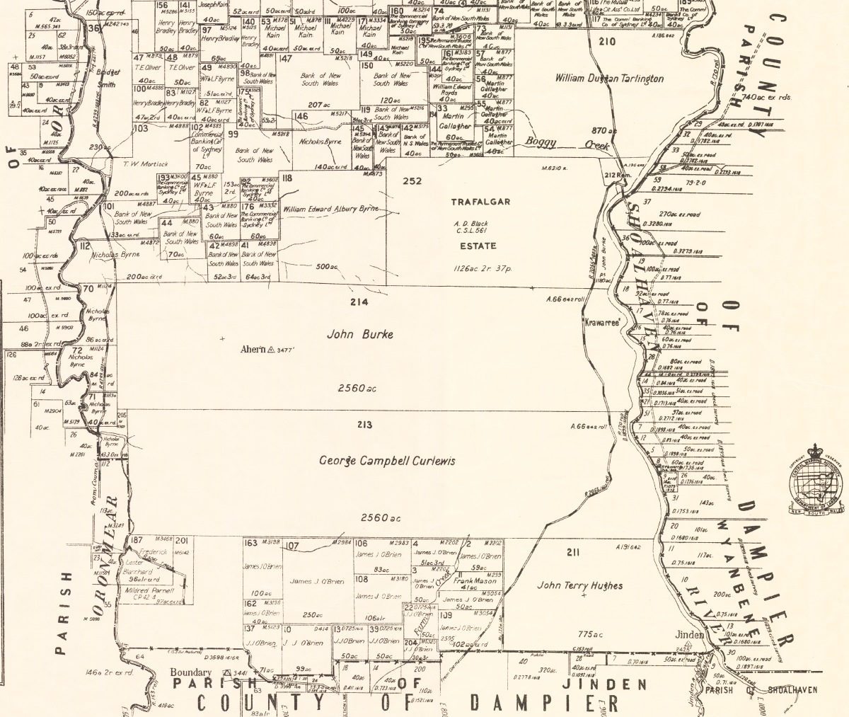 |
North (incl. Bunhybee, centre) |
Central |
South |
 |
 |
Map Title |
Map Legend |
What is now Bunhybee was (just) within the original 19 counties defined by Governor Darling in 1824-29. It was in the County of Murray, which extended north and west, as far as Yass. The Parish within the County was un-named until at least 1843, later the Parish of Ballalaba, and later again the Parish of Krawaree. The southern boundary of the Ballalaba Parish (which was the 'limit of settlement' at the time), appears to have been an east-west line at Jinden, 20km south.
The land west of what was then Oroonmeir Creek and is now Jerrabattgulla Creek was in another Parish, initially unnamed, later called the Parish of Ollalulla. To the east, on the other side of the Shoalhaven, was the County of St Vincent, which went down to the coast. (The Counties and Cadastral Parishes still exist, but have little significance now, except for history research).
'Tallaganda' / 'Oranmeir'. The first grant nearby was 4km north of Bunhybee. A Tallaganda Shire history document says that Tallaganda was an 1828 grant of 200 acres to the emancipated convict John Tarlington. It was at the confluence of the then Oroonmeir Creek, now Jerrabattgulla Creek, with the Shoalhaven, more specifically to the East and South of the confluence (at the top of the first map above). The place-name Togganoggera was applied to the area during the following years, and the property includes the bridge over the Jerrabattgulla just before it joins the Shoalhaven.
The ex-convict John Tarlington (c.1765-1842) would have been 63 at the time, and it seems likely he remained in Sydney all his life. So the property may have been bought in his name by his very energetic and much more famous step-son, William Dug[g]an Tarlin[g]ton (1806-1893). The younger Tarlin[g]ton appears to have been at this property 1827-32, and the property-name Oranmeir appears in some documents. (During the mid-twentieth century, the property was owned by the Warrens, then – as Red Hill Stud – by three doctors including Cairns and Templeton. It was bought in the 1980s by the Izzards).
In 1838, W.D.Tarlin[g]ton purchased an 870-acre property, 10km further up the Shoalhaven, with Kain's Road on its northern boundary, 7km SSE of Bunhybee (bottom-right of the second map above). But by then he was primarily at Cobargo, 100km south and east.
The site for what became Braidwood town centre was chosen in 1833, including part of Dr Wilson's property, and the town was surveyed in 1839. In 1841, Braidwood Farm had 141 residents. The primary activity there and elsewhere in the district was, and remained for the following century, the production of wool.
Krawar(r)ee, 40km south of Braidwood, in the Shoalhaven valley, 24km south of the Togganoggera bridge, was an 1840 grant to Captain Grant, of H.M 61st Regiment of foot. (But Krawarree was also the name given to the small, 2,700' peak 2km to the south of Bunhybee).
Ballalaba, 10km north of Bunhybee, and immediately NW of the corner of the Cooma and Captain's Flat Roads was a grant of 1840, to a Royd. In about 1860, the owner was T.J. Roberts. It is one of two locations claimed as the birthplace of Archer, winner of the first two Melbourne Cups in 1861 and 1862. A Tallaganda Shire history document says that two more Melbourne Cup winners were bred there – Tim Whiffler (1867) and Bravo (1889). The Royd family still owns the property, together with several other large properties in the district.
Gilston is 2km south of Bunhybee, on the western side of the Jerrabattgully and immediately SW of Warragandra. It dates from some time before 1847. It was owned intially by a Hart, along with blocks on the eastern side of the Jerrabattgulla Road. Hart's Rd is the name assigned in recent years to the old mail road that runs E-W to the south of Bunhybee and the adjacent Parlour Grasslands, from Warrangandra homestead over the saddle to the Shoalhaven valley.
A page of the Whaite family history identifies a Joseph Hart (1837-1910) b. in Liverpool (UK), whose family migrated to Australia in 1840. He was married on 25 Sep 1856 in Braidwood to Honora (Anna) (Kane) (from Tipperary 1831/35-1925), Burial Witnesses: P G Kain, E Torpy. A posting says that an Ellen Ross was married on 1 May 1847 in "Presbyterian Church, Gilston near Braidwood, NSW". No other mention of a Church on the property has been found. Maybe the ceremony was conducted on the property by a visiting Minister from Braidwood or Queanbeyan? More research is needed in the Monaro Pioneers Database. A Hart who died in 1877 is mentioned in the context of Gilston. Gilston is now in the hands of a member of the O'Connell family.
In the Maitland Mercury & Hunter River General Advertiser of 13 February 1847, it was reported that, at the Berrima Assizes on 4 Feb 1847, "George Beaton was found guilty of the wilful murder of John Kelly, at Ornmeir Creek, on the 24th December. The prisoner attacked the deceased's house in the night without provocation, and when deceased came out to remonstrate with him, prisoner attacked him, and stabbed him in the belly with a knife. Prisoner, in defence, said that deceased had followed him and beat him with a stick till he was insensible, and he did not know what occurred afterwards. Mr. Justice Therry passed sentence of death on him, holding him out no hopes of mercy".
"Gold was discovered [SE of Braidwood] in 1851, and for the next two decades the district's population swelled to about 10,000. Supplies and produce to support the workforce on the gold fields came from as far afield as the Canberra region. This prosperity lasted for several years, during which some substantial commercial buildings including banks and hotels were constructed [in Braidwood]". Here is Braidwood's own history-page, and here is the Braidwood Museum and the Historical Society.
On 7 Jul 1859 in 'The Empire' in Sydney, a request for a Post Office at Oranmeir was supported by the statement that "large populations are growing up at ... Oranmeir".
Close to the road south from Braidwood towards Bunhybee, is Jembaicumbene. One of the properties there is one of the two places claimed as the birthplace of Archer, winner of the first two Melbourne Cups in 1861 and 1862. "Foaled at the 'Exeter Farm', it was also his last home where he was retired to stud, and where he is believed to be buried. Several other Melbourne Cup winners were also bred in the district. Horse racing was the most important leisure activity for the miners in the old days, and the social life for the settlers centred largely around the race meetings, held on courses which have now disappeared". Jembaicumbene has a further brush with horse-racing fame in that it was the birthplace of trainer T.J. Smith.
M.N. O'Connell of Oranmeir wrote an excellent letter to the Sydney Morning Herald in August 1860, arguing that what became the King's Highway was being put in the wrong place.
An article in the Maitland Mercury of 18 March 1862 referred to a descent into the Big Hole (10km south on the other side of the Shoalhaven), and located it by reference to Emeu [Emu] Flat, Oranmeir.
From 1862-67, "the Clarke gang of bushrangers led by brothers Tom and John Clarke of Ballalaba with uncles Pat and Tom [O']Connell of Oranmeir stole horses, robbed travellers, stores, hotels, homesteads". They were captured in April 1867 and hanged in June 1867. Here is one rendition of the story, and here is an 1866 newspaper report on a related matter. Thomas Clarke had married Charlotte Hart in 1863. She was the daughter of Michael Hart, an ex-convict who had arrived in 1827, had land in the area (including one-third of Bunhybee for a short time). She is reputed to have disowned her husband soon afterwards, when he became so infamous that he now has an entry in the Australian Dictionary of Biography.
"Braidwood was the subject of the nation's first Royal Commission in 1867, inquiring into the activities of police officers and managers in the district, concerning the extent to which bushrangers had been shielded and assisted by police connivance and inactivity. The Commission identified several instances of misconduct and found the superintendent of police had failed to exercise 'strict and proper control over his men'".
Here's the local newspaper's report on a 'Police and Bushrangers Descendants event' held in the area on Saturday 26 September 2015, 148 years after the climax of the Clarke gang phase (mirrored here).
More Crown Land Sales in the area were reported in The Queanbeyan Age in April 1869.
In 1875, Mr George Szarka, half-time school teacher at Oranmeir and Jerrabatgully, "met with an accident of a most extraordinary character".
A Jerrabattgulla Public School was established in 1892 (and closed only in 1957).
The death of a "well-known and prosperous farmer" Henry Warren was reported on Oranmeir in 1907.
St Pauls Anglican Ballalaba was built in 1913, 8km north of the place-name on most maps, just north of the bridge over the Shoalhaven and just south of Bendoura.
21 votes were cast at Oranmeir in the 1918 election.
A D.M. O'Connell was at Oranmeir in March 1920. In 2011, both Oranmeir and Gilston are owned by O'Connells.
A dingo's death was widely reported in 1937.
Searches on the longstanding placename of Togganoggera have found almost nothing, although the Braidwood Times noted on 02 Jul 2002 that "Proposals to have the Tallaganda Shire Council's Works Department account for a $47,000 overspend on the Togganoggera Bridge and to address the wider problem of project overspends, were defeated at the June meeting of Council".
Tourist and cultural information is available, on people and homes, and on heritage listings in what is now Palerang Shire.
Created: 23 February 2009; Last Amended: 8 October 2011, 18 October 2015