Linda and Roger's Bunhybee Grasslands - Grazing
This is a page within Roger and Linda's
Bunhybee Grasslands Web-Site.
Bunhybee Grasslands is a 49 hectare / 120 acre conservation
property 35km south of Braidwood, in southern N.S.W.
You can follow through the internal links, or you may find it
easier to use the Site-Map.
Background
This page contains information about the grazing strategy for the property.
The strategy reflects our current understanding of
the property's
history.
It seems incongruous that a native grassland that is subject to a Conservation
Agreement should be grazed at all. The reasons for conducting grazing appear
to be that:
- The Risk of Grass Growth Reducing the Diversity of Native Plants.
The property is currently a balance between grasses and about 100 species
of forbs (i.e.
small native
plants
that fit
in the
spaces
between
the
predominantly tussocky grasses). If the property is left entirely to its
own devices, the grass will take over (particularly the kangaroo grass),
and the forbs will be squeezed out. ("... Too much grass biomass can
effectively “choke“ out
the diversity of forbs, herbs, lichens, mosses, orchids, etc. that rely on
the inter-tussock spaces as habitat to grow and germinate from" – Plan
of Management, p. 16)
- The Possible/Probable Beneficial Effects of (Light) Grazing.
The property may be in its present, highly desirable state due to light grazing
having
been
conducted
reasonably
consistently (at least up until about 2000 and by sheep),
or crash
grazing
conducted
from time to time (cattle, in two short periods since 2000). It simply isn't
known. Some amount of experimentation may be necessary in order to find out.
("Stock grazing has performed the service of grass biomass removal for the
last few decades" – p. 16)
- The Risk of Excessive Fuel-Load Inviting Devastating Fire.
The fuel load of dense native grasses is sufficient to create a fire hazard
(as
advised
by
David
O'Connell, 1km away, and an ex-RFS Fire Chief). There
are only
a couple of ways
to
reduce
fuel-load. One is grazing. The other is a fire, whether a natural grass-fire
or controlled burning
On the other hand, reasons to not graze, or minimise grazing, include:
- The Introduction of Weeds. Animals carry seeds on their
hooves, on their hides, and in their intestines. They come from properties
that have
improved pasture
(i.e. non-native grasses) and weeds. Even in the case of local animals, some
of the grasses and weeds aren't currently on Bunhybee. And the further afield
the animals come from, the more likely they carry seeds that are not a current
problem on the property
- Damage to the Ground. Animals do damage. Cattle's
hooves do more damage than sheep's. Sheep's nibbling does more damage than
cattle's. Both invite weeds
- Possible Advantages to Weeds. To the extent that native
grasses are harmed by grazing, exotic plants may gain a foothold, or increase
in intensity
- Damage to Grazing-Sensitive Native Plants. The Plan of
Management gives the examples of "lilies, daisies and orchids that [are palatable
and] have been lost from much of the surrounding landscape [which has been
more intensively
grazed]" (p. 11)
- Damage to the Moister Eco-Systems. The animals are naturally
attracted to the waterlines (for the better grazing there) and the dams and
pools (for the water). The waterlines, dams and pools, being moist, are softer,
and hence more amenable to damage from the animals' hooves. Some flora and
fauna (e.g. frogs, which are present) are utterly dependent on these areas
The following sections present the following information:
- the state of knowledge at the date of purchase
- local knowledge acquired since the date of purchase
- implications
- elements of a strategy for 2009-10
- our current intentions
The State of Knowledge at the Date of Purchase
This is summarised in the Plan of Management, from which the following quotations
are taken. Most of the emphases have been added. Those in the original are
noted accordingly.
"'The Parlour Paddock' has a long history of grazing by sheep
and more recently cattle. The two large paddocks were historically
set stocked by sheep at low rates, predominately due to the paucity of water
in the paddocks.
There is no history of cultivation and fertilizer was only applied once to
the Jerrabatgulla valley paddock (Pers. Comm. David O’Connell Dec 2007).
There is evidence of clearing across “The Parlour Paddock” particularly
of the Snow Gum Woodland community occurring on the lower slopes. The
area has been burnt at some time in recent decades, with fire scars
present on trees in the forested slopes of Bunhybee Hill" (Plan of Management
p. 5).
NCT's Nigel Jones advised on 18 Feb 09 that "Previous to the famous 9
(10?) whilst the property was for sale [i.e. during 2007?], there was black
cattle grazing for around 7 months ... not sure of numbers but safe
to say
30-40 across - both properties [presumably 2005-06?] ... Unfortunately
a bit of pugging
occurred during Spring ...". We think 'pugging' means
(highly undesirable) soil compaction arising from grazing on wet soil and grass.
Grazing Management is discussed on pp. 11-18 of the Plan of Management, incl.
photographs.
It is concluded that " the high floral diversity indicates a conservative
stocking rate between one and two Dry Sheep Equivalent (DSE)/ ha (with
one DSE representing a 55 kg wether). A low stocking rate/ha needs to be kept
in place if domestic stock are to be kept for longer
periods (e.g. a few months per year) on the property. However if stock
are to be used only occasionally throughout the year, i.e. as
part of a crash grazing regime where higher densities are used over a short time period, then
stocking rates will need to be adjusted accordingly. Stocking rates may also
need to be adjusted to take into account additional grazing pressure from kangaroos.
"Getting the right balance in integrating grazing and
conservation management
will require experience and evolve over time in response to
varying factors, and so the best management will need to be dynamic and adaptive.
Success in meeting the goals will rely on good on-going monitoring and communication
between the landholder and the Trust, and a developed understanding of practical
management conditions for grazing of the Conservation
Area" (p.11).
The 'Grazing Management Goals' were defined (p.12) as:
- Allow native ground cover species to be able to flower, set seed
and increase their abundance
- Allow for natural regeneration of woody shrubs
and trees in woodland
areas
- Avoid creating areas of bare ground through overgrazing
- Avoid creating
areas of dense grass swards through a lack of disturbance
[Note that some of the wet grassland (Zone 4) had dense grass swards
at the outset]
- Maintain native
ground cover in good condition
"Whilst the Trust and local extension staff will be available to offer recommendations
on a suitable grazing regime, the restoration and maintenance of Bunhybee Grasslands
will ultimately rely on the experience of the Landholder to
judge the timing of moving and excluding stock at the right time to keep the
native ground cover in good condition.
"Factors which indicate native ground cover vegetation in a good condition
are:
- retained high level of vegetative ground cover (> 80% which includes
any mosses and lichens)
- tussocks of grass tall and spreading in shape during spring/summer
(may include standing dry matter) ["grass height ranges from 5 to 15cm for
wallaby grass", but about 20cm in mid-summer 2008-09; and ">
15cm for kangaroo grass", but about 50cm in mid-summer 2008-09]
- retained/increased diversity of herbs (especially palatable species
such as orchids)
- small open spaces maintained between grass tussocks (which may
be covered by mosses and lichens)
- presence of new low/prostrate shrub regeneration and/or actively
growing tips in mid-spring
- evidence that native grasses have set and dispersed seed
- retained cover of litter (dry plant matter)" (p. 12, emphasis in original).
"[Conversely, ]Native ground cover is generally regarded as deteriorated due
to over grazing if any of the following factors are observed across the majority
of the Conservation Area:
- significant increase in cover of bare ground,
- the average grass height is
below 2cm high,
- tussocks of taller species such as kangaroo grass (Themeda
australis)
are narrowed (not spreading) and less than 15cm high,
- woody shrub/tree regeneration present has
a majority of growing stems
chewed off
- stock are markedly browsing less palatable plants such
as Purple wiregrass (Aristida ramosa) and Poa Tussock (Poa labillardieri)"
(p. 15).
"Native ground cover is generally regarded as deteriorated due
to under grazing if monitoring by
the Landholder and/or the Trust indicates a marked decrease in the
area of inter-tussock spaces combined with a significant increase
in cover of tussock grasses (including standing dry matter) across
the majority of the paddock" (p. 16). [We interpret this to mean that
the height of
native grasses (e.g. wallaby grass 20cm, kangaroo grass 50cm) is not an
indicator of deterioration, whereas density is.]
"A rest (spell) over spring/summer allows many/most native species to produce
seeds and favours seedling recruitment. Grazing during spring/summer may also
favour weed species ... These species quickly colonise bare ground and suppress/displace
some native species, particularly the small herbs" (p. 14).
Grazing Management Conditions [5.3(e)] are defined as follows (p. 17):
- Native ground cover will be maintained in “good” condition,
as defined in this plan
- Grazing must not occur from the start of September
to the end of January to allow plants to flower and set seed (this
period will be dependant on monitoring and may be subject to change)
- If the condition of the native ground cover has deteriorated due to
over
grazing, then the Landholder will decrease/remove stock immediately or when
practical in the short term, until the paddock has been restored to at least
good condition
- If the condition
of the native ground cover has deteriorated due to under
grazing, then the Landholder will reintroduce/increase stock immediately
or when practical in the short term, until the paddock has been restored
to at least good condition
- To reduce the
risk of introducing weed species, supplementary feeding of fodder
or grain [if at all!!] is to occur outside of the Conservation
Area (or within a designated feed-out area)
- Following a fire, stock must be excluded (where practicable) from the
burnt area until the regeneration is sufficient to sustain the pressure
of stock grazing
Grazing Management Recommendations were defined as follows (p. 18):
- Due to the grazing history of the Land, sheep are preferred over
cattle as they will have a lighter impact on fragile plants and ground cover, particularly
in the wet grassland
communities
- If stock are to be brought in from outside the local Braidwood
region – they
should be quarantined for a period of 6 days in a holding paddock, preferably
located outside of the Conservation Area, or in a temporarily fenced area
(of lower plant diversity) close to the road to reduce the potential of
new weed
species introductions
- Consider new internal
or temporary fencing if required to suit grazing
regime – consult
the Trust or the Southern Rivers CMA as incentives may be available
- Monitoring of condition
will need to be more regular if using rotational
grazing with large stocking rates (crash grazing). Crash grazing can be a
useful management tool to minimize selectivity of stock and maximize their
ability
to control weeds and/or manipulate the diversity of the grass sward
- Avoid using vehicles to muster stock due to risk of soil
compaction damage – mustering
by foot or on horseback is preferable
- The Landholder/s should keep a record of the
stock numbers and grazing
duration so that grazing intensity (DSE/ha/time) can be calculated and
used to guide future management decisions
Local Knowledge Acquired Since the Date of Purchase
We've met and/or had phone conversations with Di Izzard (neighbour to the
north incl. the incursion on the NW, who's been there over 10 years and whose
deceased husband was from the district), Kitty and Harry Tischler (neighbour
to the west, at 'Warragandra', who moved there
about
2002)
and David
and Jeanette
O'Connell (immediately to the west of 'Warragandra', 5 generations in the district,
and
at some stage
captain of the local Rural Fire Service).
According to David O'Connell, the 'Parlour Paddock', from about 1960 to
2000, carried sheep (merinos, of course), prettymuch constantly, of the order
of
650-700 head. The Parlour Paddock was 403 or 424 ha; so assuming on average
50kg wethers, that's 1.5-1.7 DSE/ha/p.a.
That's consistent with what
appears to be the appropriate page at DPI, which rates "good quality
native pasture, e.g. wallaby grass", at 1.5–3.0 DSE/ha/pa.
For 403 or 424 ha, that's 600-1272 DSE. There
is limited access to water throughout the old Parlour Paddock (and even less
on the northern segment that is now Bunhybee Grasslands), so the bottom end
of the
range would appear to have been about right.
Allowance needs to be made for kangaroo-grazing. Although a mob is resident
on Bunhybee Peak, and one or two have been on the upper edge of the property
most times we've been there, they do not seem to have ventured down to the
wetter areas much during 2008.
Allowance may need to ne made for grazing by ferals, in particular pigs. The
primary impact appears to have been bare patches arising from them grubbing
for roots. This peaked in mid-2008, but seems to have eased off in late 2008.
According to both David O'Connell and Kitty and Harry Tischler, little grazing
was conducted at all during
the period 2002-07. That is consistent with the state of the fencing in late
2008 prior to the sale, along the road and up against Bunhybee Peak –
fencing that cattle would have strolled through – and did.
Cattle appear to have only ever on the property in two periods, briefly in
the mid-2000s, followed by the famous 8-12 head early in NCT's time, which
strolled through
the inadequate
fencing and had to be 'rescued' by Lauren van Dyke and moved to Scotsdale
[in late
2007? – to be confirmed].
Availability of sheep for agistment is limited, because there are few in the
region now (because the returns are so low). The main use of pasture in the
district is for
cattle these days.
However,
the
dam
surrounds
are
weak,
and,
with very limited water available, the damage that cattle would do to the dam
area would probably be substantial. Di Izzard warns that the UK breeds are
more likely to find the gaps in the fences (e.g. on the several wombat tracks),
so merinos are preferable.
David O'Connell remarked that the paddocks were a fire-risk. Based on the
RFS map, we're at the southern end of Palerang zone; but that's not much
use, because it merely tells us that RFS zones are based on Local Government
Areas. Looks like 'local knowledge' still beats the Web ...
Implications for Bunhybee
Summarising NCT's thinking as at 2007-08, they had a preference for:
- grazing as the control mechanism
- sheep (because of hoof- and weight damage from cattle)
- local mobs (because of the higher risk of importing weeds with non-local
stock)
- crash-grazing, i.e. "a big mob for a short period rather than a small
mob for a long time" ("as a small mob are more selective to herbs
and forbs instead of eating the grasses") – quotes from Nigel Jones'
email of 18 Feb 2009
- late summer / early autumn grazing, after seeding and before winter
Based on:
- the area of 48 hectares
- the DPI figure of 1.5-3 DSE/ha/p.a.
- the historical carrying
capacity on the Parlour Grasslands as a whole 1.5-1.7 DSE/ha.p.a.
- the
limited
water available (less than on the other
three parts of the old Parlour)
what seems appropriate for Bunhybee is a DSE/ha/p.a. of at most 1.
That
suggests a carrying capacity
of 50 x 50kg wethers, year-round.
For very light crash-grazing for 3-4 weeks, the equivalent might
be a mob of 150?
The target time-period is February-April.
Elements of a Strategy for 2009-2010
1. Differentiate Areas
|
The need for grazing
to control grass-growth varies between areas, and grazing in the poorer-quality
grasslands could be harmful. So areas need to be distinguished.
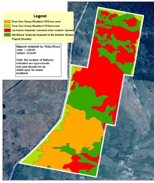
The Plan of Management identifies "four Grazing Zones, which are based on
the vegetation communities’ management needs (see Map 3). Zone 1 and
2 are Snow Gum Woodland areas which vary in tree and shrub cover across the
Conservation Area. Zones 3 and 4 are areas of dry and wet Natural Temperate
Grassland" (p.11).
We have in mind to declare Zone 5 - Wet Areas, because they have distinctly different ecologies,
have quite different vulnerabilities and probably risks, and need quite different management.
Grass growth is
greatest in the wet grassland areas (Zone 4). But we need to check that all
areas within Zone 4 are comparable to one another.
It appears to us that the dry grassland (Zone 3) varies
a great deal. We need to map the parts with more vigorous grass-growth (and
that presumably
have better soil and/or are subject to more frequent watering and/or less frequent
or intensive kangaroo-grazing).
The Snow Gum Woodland (Zones 1 and 2) is mostly quite sparse. We need to check
whether any parts of it warrant grazing at this stage.
We may need to specify for-grazing and not-for-grazing segments.
|
 |
2. Consider Controlled Burning
It may be that the high-grassgrowth / high-fuel-load areas can be controlled
by learning the technique of doing low-temperature acre-sized burns, or inviting
the local Rural Fire Service to come and do a practice-run. ("Without grazing
or fire, the native ground cover at ‘Bunhybee’ Grasslands may become
less diverse" – Plan of Management,
p. 14).
An attempt at a systemic explanation of this might be:
- grasslands existed before white man's sheep
and cows (although, admittedly, whether this particular grassland did we
don't know)
- fire is natural
- the kinds of high-intensity fires that
occurred in Canberra in 2003 and in Victoria in 2009 aren't natural (or
at least didn't used to be)
- but low-intensity fires are natural
- the fires that seem likely to have been
lit by aboriginals may have been generally of low intensity (on the assumption
that they would have not done it in high-danger periods)
Hence:
- if kangaroos can't graze it fast enough, then the nearest thing to a natural
control isn't white man's animals but low-intensity fire
3. Consider differential controls in different segments
Zone 4 appears to be most at risk of loss of species diversity, because that
is where the native grasses are very dense, and forbs appear to have been already
squeezed out. (But is this natural anyway?). On the other hand, this area appears
not to be a significant fire-risk in the current, reasonable conditions.
The 'lushest' segments of Zone 3 may be both at some risk of loss of species
diversity and higher fire-risk.
So a mix of grazing and controlled burning in different segments might be
more appropriate than one or the other.
Mowing and patch burning are other possibilities.
4. Investigate means of controlling agisted stock:
- portable fencing, to keep them on intended sections and
off others (particularly the dams and the waterlines, but possibly also areas
in which grass-growth
is neither threatening forbs nor creating a significant fire-risk)
- means of watering stock without providing them with access
to the dams and the pools in the waterlines (e.g. troughs, pipes and pumps)
5. Investigate the practicalities of agisting stock:
- what are the water requirements for 150 head for 3-4 weeks?
- where do we get a standard agistment agreement? [This is essential, in
order to be clear about questions concerning the recent locations of the
stock and/or quarantine, watering, the preclusion of hand-feeding,
and responsibilities and risks,
e.g. fence
integrity,
fence
maintenance,
liability for animals on the road]
- who is a likely agister? [At this stage, Di Izzard for sheep. If we consider
cattle (e.g. by putting up temporary electric fencing to protect the dams
and water-lines, and coming up with alternative watering arrangements), then
David O'Connell
is a possibility]
- what are normal agistment rates, and how much less convenient will this
kind of arrangement be for the agister?
Our Current Intentions
Hold off on grazing in autumn 2009.
Map the areas in which grass-growth is an issue.
Track down David Eddy, who has written a book on the topic, and discuss it
with him.
Probably do, or arrange, a small trial controlled burn.
Research fencing and watering, and build and maintain our local contacts,
so that grazing can be arranged quickly if we change our minds.
Reference:
Eddy D. (2002) 'Managing Native Grassland: a guide to management for conservation,
production and landscape protection' WWF, 2002
Contact: Linda or Roger
Created: 23 February 2009; Last Amended: 1 March 2009