Linda and Roger's Bunhybee Grasslands
History
This is a page within Roger and Linda's
Bunhybee Grasslands Web-Site.
Bunhybee Grasslands is a 49 hectare / 120 acre conservation
property 35km south of Braidwood, in southern N.S.W.
You can follow through the internal links, or you may find it
easier to use the Site-Map.
This page commences with some general historical information about
the district.
A separate page provides information about the history
of the property itself.
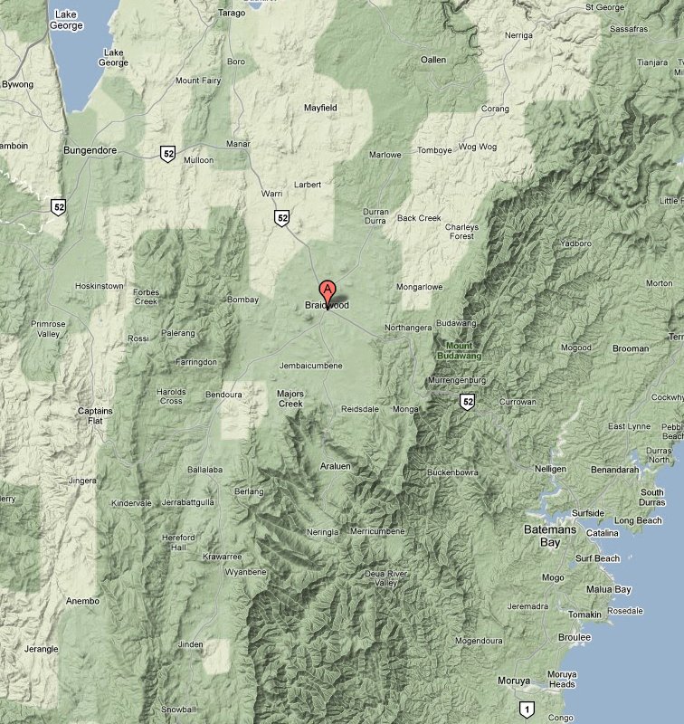
The Braidwood District
|
|
|
District Map
Bunhybee is SSW of
Braidwood, between
Ballalaba and Jerrabattgulla |
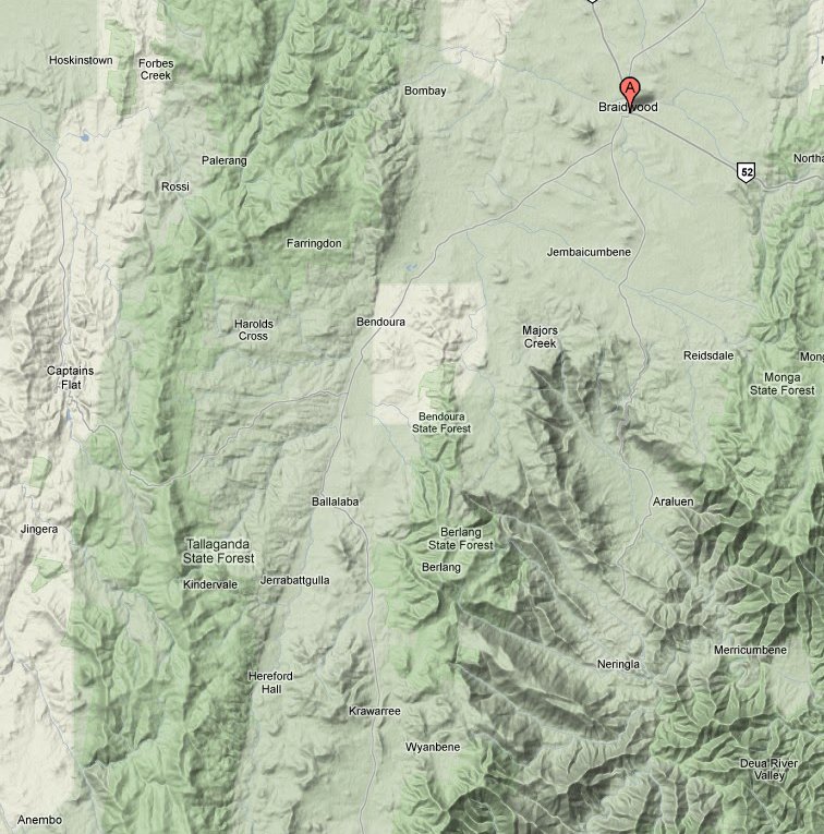
Local Map
Bunhybee is between
Ballalaba and Jerrabattgulla
which are 5km apart
Click a Map to enlarge it
|
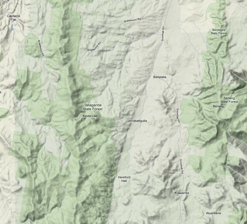
Property Map
Bunhybee is between
Ballalaba and Jerrabattgulla,
just west of Bunhybee Peak |
Braidwood lies 200km SSW of Sydney, 60km ESE of Canberra and 40km
NW of Bateman's Bay. It is on the plateau, 20km west of the coastal escarpment.
The Wikipedia
entry and a page on the Visit
Braidwood site both say that European explorers by the name of Kearns, Marsh
and Packer reached the Braidwood district in 1822. They were sent to investigate
the possibility of a track between the Limestone plains (the current site of
Canberra) and Batemans Bay.
The area was first settled by Europeans in the 1820s, and the
town was surveyed in 1839. In 1841 Braidwood Farm had 141 residents. The primary
activity was, and remained for the following century, the production of wool.
"Braidwood was the subject of the nation's first Royal Commission
in 1867, inquiring into the activities of police officers and managers in the
district, concerning the extent to which bushrangers had been shielded and assisted
by police connivance and inactivity. The Commission identified several instances
of misconduct and found the superintendent of police had failed to exercise
'strict and proper control over his men'". (There have been many since,
and there should have been a lot more).
"Gold was discovered in 1851, and for the next two decades
the district's population swelled to about 10,000. Supplies and produce to support
the workforce on the gold fields came from as far afield as the Canberra region.
This prosperity lasted for several years, during which some substantial commercial
buildings including banks and hotels were constructed". [This is irrelevant,
but fun: Local legend has it that Mick Jagger wrote one of his major hits while
on location to make Ned Kelly; but there is no agreement as to which one.] Here
is the town's own history-page,
and here is the Braidwood Museum
and the Historical Society.
According to Major's
Creek's own history page, this nearby area was first settled by
Major William Sandys Elrington, who received a free grant in 1827 of 2650 acres.
On the road south from Braidwood towards Bunhybee, is Jembaicumbene.
Among other things, it was the birthplace of Archer, winner of the first two
Melbourne Cups in 1861 and 1862. "Foaled at the 'Exeter Farm', it was also
his last home where he was retired to stud, and where he is believed to be buried.
Several other Melbourne Cup winners were also bred in the district. Horse racing
was the most important leisure activity for the miners in the old days, and
the social life for the settlers centred largely around the race meetings, held
on courses which have now disappeared". Jembaicumbene has a further, although
more remote brush with horse-racing fame in that it was the birthplace of trainer
T.J. Smith. However, a
Tallaganda Shire history document attributes Archer to T.J. Roberts at Ballalaba
rather than Jembaicumbene. And it says that two more Melbourne Cup winners were
bred there – Tim Whiffler (1867) and Bravo (1889).
To the south and west of Bunhybee, the Shire document says that Tallaganda
was an 1828 grant of 200 acres to the emancipated convict John Tarlington. Tallaganda
is thought to be the Aboriginal name for all of the valley within 20 miles of
the rising of the Shoalhaven River. Krawaree was an 1840 grant
to Captain Grant, of H.M 61st Regiment of foot.
A place-name close to Bunhybee is Ballalaba, which appears
to be an area of fairly flexible extent, 4-10km north. The property Ballalaba
was a grant of 1840. St
Pauls Anglican Ballalaba, built in 1913, is some distance north, just north
of the Shoalhaven crossing and 12km from Bunhybee.
The property adjacent to Bunhybee, over the ridge-line to the east, is Oranmeir,
previously spelt Oronmear. This was an 870-acre property purchased by William
Tarlinton in 1838. He had taken the name of his stepfather (the grantee of Tallaganda
mentioned above). On 7 Jul 1859 in
'The Empire' in Sydney, a request for a Post Office at Oranmeir was supported
by the statement that "large populations are growing up at ... Oranmeir".
M.N. O'Connell of Oranmeir wrote an
excellent letter to the Sydney Morning Herald in August 1860, arguing that
what became the King's Highway was being put in the wrong place. He has a point.
An article in the Maitland
Mercury of 18 March 1862 located a descent into the Big Hole (10km south
and across the Shoalhaven) by reference to Oranmeir.
From 1862-67, "the Clarke gang of bushrangers led by brothers Tom and
John Clarke of Ballalaba with uncles Pat and Tom [O']Connell of Oranmeir stole
horses, robbed travellers, stores, hotels, homesteads". They were captured
in April 1867 and hanged in June 1867. Here is one
rendition of the story, and here is an
1866 newspaper report on a related matter.
Michael Hart, an ex-convict who had arrived in 1827, had land in the area (including
one-third of Bunhybee for a short time), and a daughter who married Thomas Clarke
in 1863 and had his child, but disowned him soon afterwards, when he becameso
infamous that he has an entry in the Australian
Dictionary of Biography.
Crown Land Sales in the area were reported
in The Queanbeyan Age in April 1869.
The death of a "well-known and prosperous farmer" Henry Warren was
reported on the property in 1907. 21 votes
were cast in the 1918 election. A D.M. O'Connell was there in March 1920.
A dingo's
death was widely reported in 1937. In 2011, Oranmeir is still owned by an
O'Connell.
Bunhybee lies on the upper slopes of Jerrabattgulla Creek.
However there are mentions of it also as Jerrabattgully. According
to a
list of NSW rivers, Jerrabattgulla Creek was previously Oronmear
Creek. A report exists of the upper Jerrabattgulla Creek / Krawaree
West area as seen from a
regolith science (i.e. mining company) perspective in 2004.
The place-name Jerrabattgulla, is 3km to the south of Bunhybee.
There is little to be found on the Web in that name, although there is mention
of the Jerrabattgulla
Public School, 1892-1957. There are mentions in earlier times of its older
name, e.g. in
1875, Mr George Szarka, half-time school teacher at Oranmeir and Jerrabatgully,
"met with an accident of a most extraordinary character".
The centre section of the Jerrabattgulla valley was occupied by the Warragandra
property. Warragandra's history, and how Bunhybee came to be carved
off from it, is discussed on a separate page.
On the western side of the Jerrabattgully, SW of Warragandra and 2km from Bunhybee,
is the Gilston property. It has been owned for some years by
a member of the O'Connell family. A Hart, who died in1877 is mentioned in the
context of Gilston. Hart's Rd runs E-W to the south of Bunhybee and the adjacent
Parlour Grasslands, between Warrangandra and Oranmeir. A page
of the Whaite family history identifies a Joseph Hart (1837-1910) b. Liverpool
1837, whose family migrated to Australia 1840. He was married on 25 Sep 1856
in Braidwood to Honora (Anna) (Kane) (from Tipperary 1831/35-1925), Burial Witnesses:
P G Kain, E Torpy.
Another
reference to Gilston is intriguing, saying that an Ellen Ross was married
on 1 May 1847 in Presbyterian Church, Gilston near Braidwood, NSW. No other
mention of a Church on the property has been found. A preacher from Braidwood
or Queanbeyan might have brought his portable altar with him perhaps? This page
also mentions a 'Monaro Pioneers Database'.
In the Maitland Mercury
& Hunter River General Advertiser of 13 February 1847, it was reported
that, at the Berrima Assizes on 4 Feb 1847, George Beaton was found guilty of
the wilful murder of John Kelly, at Ornmeir Creek, on the 24th December. The
prisoner attacked the deceased's house in the night without provocation, and
when deceased came out to remonstrate with him, prisoner attacked him, and stabbed
him in the belly with a knife. Prisoner, in defence, said that deceased had
followed him and beat him with a stick till he was insensible, and he did not
know what occurred afterwards. Mr. Justice Therry passed sentence of death on
him, holding him out no hopes of mercy.
These days, Gilston is an
official rainfall monitoring station. The homestead is subject to heritage
constraints.
The sole reference found to date for Bunhybee Peak is in
"a
Schedule of Principal Mts., etc", in the Qeensland Geographical Journal
including the proceedings of the Royal Geographical Society of Australasia,
Queensland, Volumes 5-10, 1889 (cover digitised from the Uni of Michigan Library).
Gundillion Cemetery
(also known as Emu Creek Cemetery) is 10km SE, as the crow
flies, on the eastern side of Snowball Rd. The Inscription
List includes a number of Harts and O'Connells. I'm not aware of any other
nearby cemeteries.
Searches on the longstanding placename of Togganoggera have
found almost nothing, although the
Braidwood Times noted on 02 Jul 02 that "Proposals to have the Tallaganda
Shire Council's Works Department account for a $47,000 overspend on the Togganoggera
Bridge and to address the wider problem of project overspends, were defeated
at the June meeting of Council".
A separate page provides information about the
history of the property itself.
Contact: Linda or Roger
Created: 23 February 2009; Last Amended: 30 September 2011