This is a page within Roger and Linda's
Bunhybee Grasslands Web-Site.
Bunhybee Grasslands is a 49ha/120-acre conservation property 35km south of Braidwood,
in sthn N.S.W.
You can follow through the internal links, or you may find it easier to use
the Site-Map.
Bunhybee Grasslands is a prime example of native southern temperate grassland. This page provides what we know in relation to the following aspects:
There are companion pages on:
Bunhybee Grasslands is in the NSW Southern Tablelands, 4km
up a side-valley of the Shoalhaven River.
It's 35km south of Braidwood.
It's 8km almost due east of the 'Canberra' radar
station on Mt Cowangerong (1358m, 35.66° S 149.51° E).
It's about 14km slightly south of west from Araluen (although only if you're a bird).
It lies at an altitude of between 710 and 760 metres.
It's just on the Pacific side
of the 1200-1300m Tallaganda Range, which is part of the Great Dividing Range.
Here's a very broad area-map / satellite view.
The property gained a street-address c. 2012, as 359 Jerrabattgulla Rd, Krawaree. (According to the Council's surveyor, the gate is 3.59km south of the junction with Cooma / Krawaree Rd. But Google Maps can't cope with that address).
Based on the Kain 1:25,000-series map, the middle of the middle Lot (Lot 165) is at about Latitude S35/40/40 or -35.6778 and Longitude E149/46/30 or 149.6083. One set of GPS readings at the middle of the house-location gave S35/40/385, E149/36/582, and elevation 2500ft (762m) +/- 30m (all of which are verrry close to the map-coordinates). Based on experiments with Google Maps, the gate is at 35°40'27.0"S 149°36'22.0"E, and this map marks the gate, with the property extending c.700m north, c.560m south, and on average 410m east.
Here is the Google Map view, centred on the nearest place-name that Google Maps recognises, which is Jerrabattgulla, a largely notional placename, 3km south of the property (where the school may have been, once).
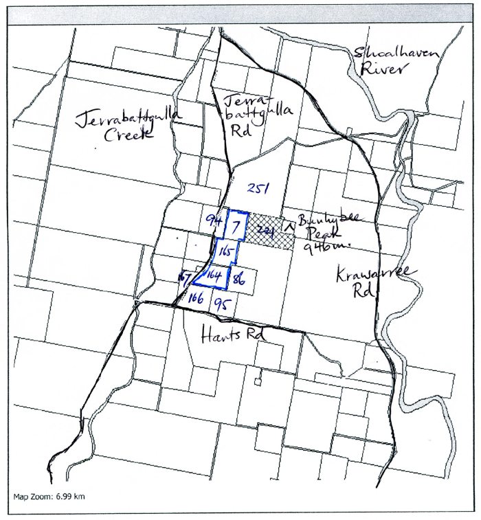
The property is bounded on the west by the 946-metre Bunhybee Peak, and on the east by Jerrabat(t)gulla Rd. It's 4km south of the intersection of Jerrabatgulla Rd with the Krawaree Rd (which runs between Braidwood and Cooma), and 1km north of the intersection with the old mail road / Harts Rd.
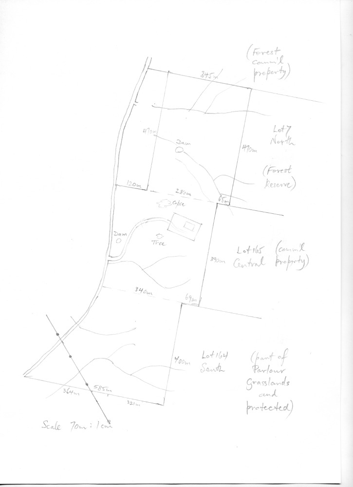
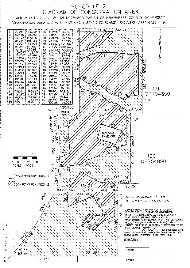
It comprises Lots 7, 165 and 164 within DP 754890, once of the Parish of Ballalaba, but latterly of the Parish of Kwawarree, County of Murray. The property as a whole runs 1260m N-S with an E-W width that averages 410m. As shown on this sketch, the Lots run from N to S, and are, respectively:
Here are:
In this local-area map are three adjacent properties, all under Conservation Agreements, originally via NCT, now administered by BCT within the State Government Department, totalling c. 190ha / 450ac:
The property is 35km south of Braidwood. These directions assume you can get yourself to that metropolis (probably pausing there for a coffee, at the Albion or one of the several other cafés):
The nearest named location on Google Maps is Jerrabattgulla, which is 3km further south. On that map, the entrance is about where the 'g' of Jerrabatgulla Rd is.
Here are Google Map's directions from Braidwood to Jerrabbattgulla, but that's 3km beyond the entrance to Bunybee.
The gate is at 35°40'27.0"S 149°36'22.0"E.
This
map marks the gate, with the property extending c.700m north, c.500m
south, and c.400m east.
Even if the gate's open, DO NOT DRIVE IN! Please protect
the grasslands from the seeds your vehicle inevitably carries, by parking on
the (very quiet) unsealed road.
We understand the area's long-term-average rainfall to be about 750 mm (30 ins) p.a., but it's highly variable, and the area is very windy and hence has a high evaporation-rate:
Here's a screenshot of the data for the last two decades
There seemed to be no Bureau of Meteorology (BoM) site anywhere in the upper Shoalhaven valley, with the nearest official climate statistics being for Braidwood and Braidwood Racecourse, both c. 35km north.
Trawling the BoM site finds this page for weather-station data. A search on 'Jerrabattgulla' finds the location 35.68° S, 149.58° E, and it says station 070261 is at Gilston, at 35.69° S 149.59° E (the next property south of Warragandra, 2.5 km SSW of Bunhybee Grasslands, and at 725m, i.e. the same altitude.
Here are the Gilston pages for daily rainfall, and monthly rainfall, mirrored here.
The extract in this spreadsheet includes a few missing months for which I've interpolated average rainfall.
The most useful weather-stations nearby are:
Other less relevant weather-stations nearby are:
The property has always had limited water available for livestock. As a result, the property has always been lightly grazed. In addition, from both local knowledge and inspection, it appears to have never been improved with fertiliser, nor with non-native, higher-food-value grasses. As a result of visits by professional and amateur ecologists, and Linda's own work, we've catalogued c. 225 native species of grasses and forbs on the property, and there are only relatively small problems with weeds.
There was a Water Catchment Authority study of the Upper Shoallhaven in 2008, mirrored here.
There are mentions in Sydney Water Supply Quality Audits in 2005 and 2007, mirrored here, and here.
A report exists of the upper Jerrabattgulla Creek / Krawaree West area as seen from a regolith science (i.e. mining company) perspective in 2004.
This is a page within the Bunhybee Grasslands Web-Site, home-page
here, and site-map here
Contact: Linda or Roger
Created: 7 October 2008; Last Amended: 17 September 2018 (re rainfall), 25 September 2021 (re the adjacent blocks)