Mountain Walks – 2022
Click on any image to see a larger version
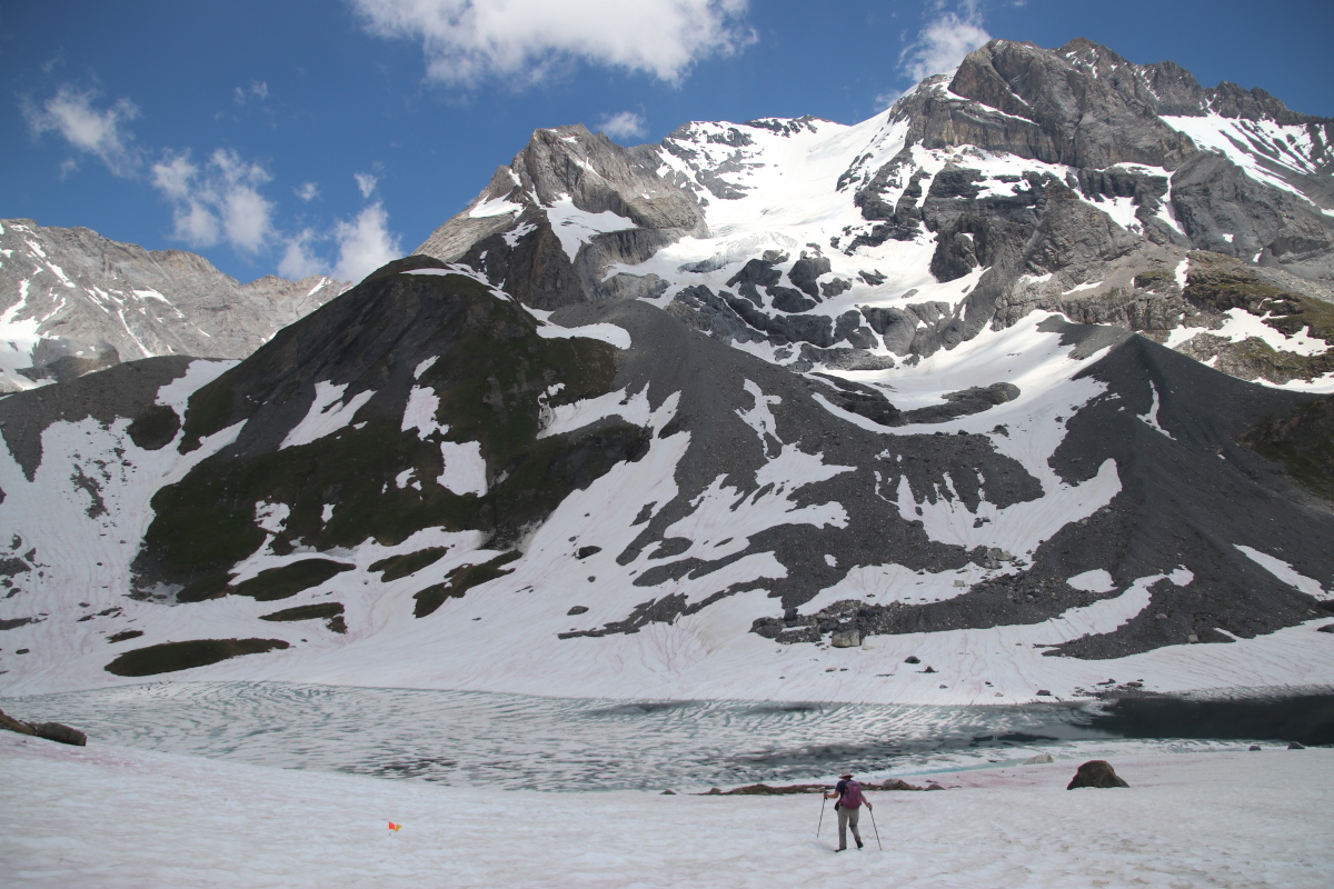
Gibraltar Rocks, in Tidbinbilla Nature Reserve - Sun 23 Jan 2022
An 8km return and +/-337m walk, 45km SW of the middle of Canberra
Just north of the 80% of Namadgi N.P. that was savaged by fire in Jan 2021
|
|
|
|
Vegetation from well up
towards the peak |
Summit wildlife,
a confident Cunningham's Skink |
Looking eastwards
30km to Canberra |
Looking northwards
along the Brindabellas |
|
The walk starts at the carpark visible above-centre, comes directly past the swamp, then bends up right (eastwards) to a saddle, along out of sight to the right, then crosses beneath the rocks and enters the granite huddle from the left (west) of the photo. |
|
|
View from the top
back NW to the carpark |
|
|
Hyacinth Orchid
Dipodium punctatum |
The Tarkine, in NW Tasmania - Tue 5 to Fri 8 Apr 2022
A series of short walks, to get to know this remote area, and warm up for the following week.
Leven Canyon - 2km, +/-100m - Tue 5 Apr 2022
SW of Devonport, 30km South of Penguin
|
|
|
|
The Canyon |
Rockpools |
Track and Vegetation |
Leven Valley, downstream |
Rocky Cape to Cathedral Beach - 5km, +/-225m - Tue 5 Apr 2022
Northern Coast, towards the western end
|
|
|
|
Burgess Cove |
The Next Cove East |
Cathedral Rocks Bay |
The Promontory to the East |
Philosopher's Walk - 6km, +/-200m - Wed 6 Apr 2022
10km east of Waratah, off the Waratah to Corinna Rd
|
|
|
Adult (not old) Myrtle
(ditto Linda) |
Young Dicksonia antarctica |
Myrtle-loving Red Fungus |
|
|
|
Mature Breadlike Shelf Fungus
with Lichen, on Myrtle |
Slime mould?, or Fungus?
with Lichen of course |
A Foliate Lichen I think
rather than a Fern |
Dove Canyon Walk, Cradle Mountain - 5.5km, +/-200m (Alltrails) - Thu 7 Apr 2022
Garmin said 7km, which felt right, and I estimated +/- 300m. It starts behind the *old* Ranger's Station (and hence requires a National Park permit). Parts are rough 'n' tough, parts very striking, and diverse; a top walk. Slow, and a good warm-up walk.
|
|
|
|
Young Myrtle Forest |
Dove Creek |
Moss, Lester, Anna |
Dove Gully |
|
|
|
|
Dove Canyon |
A short, sharp climb |
Forest to Buttongrass |
Buttongrass and Bluff |
Tasmania - The Overland Track - 71.5km, +2080m/-2230m - Mon 11 to Sat 16 Apr 2022
We've walked in this area before, in 2000, 2002 and 2007. The Overland Track is one of the world's great walks, because the landscape and vegetation are exceptional. So is the challenging nature of the track surface - 20% boardwalk, but 35% rocky and 35% tightly tree-rooted. Fortunately the vertical height is not all that great. We again used the Tasmanian Expeditions Company for our third (and probably Roger's last) cushy, hut-based trip over the top - expensive, but pleasant 6 x twin-bedroom hut-accommodation, carrying only c.9kg, with 2 well-trained and very busy guides doing all the hard work organising us, feeding us and cleaning up after us - thanks Maggie, and Francesco and Angus in relay!
Click on any image to see a larger version
|
|
|
|
Marion's Lookout and
Cradle Mt from
a Lookout 20km North |
Location |
Map, part 1 |
Map, part 2 |
Day 1 - Waldheim to Waterfall Valley - 12km, +470m/-340m - Mon 11 Apr 2022
After the setup and drive from Launceston, an 11:00-18:00 walk to the first hut. Rain and mist early on, mostly not too heavy. Cradle Mt didn't show itself until we were beneath its 300m chimney-stack wall.
|
|
|
|
From Waldheim,
starting out |
After rain,
at Crater Lake |
Nothofagus gunnii,
Deciduous Beech |
On the plateau
beneath Cradle Mt |
|
|
|
|
Linda's shot, nearby |
Barn Bluff, with
our target beneath it |
Cradle finally showing |
Mt Oakleigh to the S,
in late sun |
Day 2 - Waterfall Valley to Pine Forest Hut - 12km, +240m/-300m - Tue 12 Apr 2022
A lakeland walk, with occasional small forests, and drizzle.
|
|
|
|
Beech Path |
Euc. coccifera
Tas. Snow Gum |
Euc. subcrenulata?
(like E. stellulata)
Alpine Yellow Gum |
Forest Path |
|
|
|
|
Vegetation and Path |
Vegetation |
Lake Windermere ... |
... lakeshore views |
|
|
|
|
Pencil Pines plus Path |
Cushion Plant Commuity |
Many-lichened trunk |
The largest of the many
Richea pandanifolia |
Day 3 - Pine Forest Hut to Pelion Hut - 12km, +290m/-340m - Wed 13 Apr 2022
10km on the track plus a 2km side-trip to Old Pelion Hut. Much nicer weather, and a shorter walk; but they seem not to offer the 8km Mt Oakleigh walk these days, just a swim and a small fossil 'beach'.
|
|
|
|
Pelion West |
Looking Southwards,
incl. Pelion East,
Ossa and Paddy's Nut |
Pelion West Massif? |
Pandani Fronds |
|
|
|
|
Mt Oakleigh ... |
... and its pinnacles |
Near the swimming-hole |
Back to Pelion West |
Day 4 - Pelion Hut to Kia-Ora - 15km, +740m/-770m - Thu 14 Apr 2022
A pleasant, mostly forested 9km up to Pelion Gap and down the other side, plus a 6km, +/-500m side-trip up Mt Ossa
|
|
|
|
Forest en route to Pelion Gap |
The path |
A large, old hybrid of
Pencil and King Billy Pines |
More forest |
|
|
|
|
Not MuchRoom Left |
At Pelion Gap |
The Assault Party ... |
... En route |
|
|
|
|
The View to the South |
'The Japanese Garden' |
Looking back over
Mt Doris to Pelion East |
Ahead of us, the chminey |
|
|
|
|
Some of the summit hectare |
Gloating hikers |
The summit tarn |
The summit's exit door |
|
|
|
|
The Easy Bit |
The Less Easy Bit |
Nearlythereitis exercises
Angus the Wilderness Medic |
A final view back up |
Day 5 - Kia-Ora to Windy Ridge Hut - 11km, +280m/-270m - Fri 15 Apr 2022
10km on the track plus a 1km, +/-50m side-trip to two waterfalls
A subdued day (and a subdued Roger), wet, and deep in forest all day.
|
|
|
|
A wet start |
Myrtle forest ... |
... and dark |
With many passengers aboard |
|
|
|
|
D'Alton Falls,
the sculptures visible
due to the 'drought' |
Fergusson Falls |
Coral fungus |
A stream |
Day 6 - Windy Ridge Hut to Lake St Clair Ferry - 9.5km, +60m/-210m - Sat 16 Apr 2022
A stroll to the ferry, avoiding the 17km root-ridden track along the lake.
|
|
|
|
The path home |
Our last button-grass plain,
Mt Olympus behind |
The Narcissus River |
The group, at the wharf |
Italian and French Alps - 8 Jul to 11 Aug 2022
COVID had prevented us from walking internationally throughout 2020 and 2021. Travel remained problematic during our preferred late May to early July slot, but we bit the bullet, ran the gauntlet, and booked for 5 weeks across the peak of summer.
The locations we travelled in were:
The Ligurian Alps north of San Remo - overnight 8-9 Jul
We didn't walk, but merely overnighted. It's an isolated area, 45km but a slow 1hr drive north of the Italian coast near the French border. It's a bit rougher than the central Alps, but has plenty of great views and enough walks and enough culture that we may spend 5 or 6 days some time, with forays West to the roadless border mountains.
There are few villages, but Triora, at 780m, is a classic, well-preserved and sufficiently touristy mountain village of 400 (down from 3300 in 1861).
|
|
|
|
Our balcony view
from B&B La Stregatta |
Most of the village,
from beneath the
hilltop cimeteria |
View from a
chapel E of Triora |
Looking 40km
S to the Med |
The Alps north of Brescia — 9-12 Jul
We stayed in the town of Bagolino, at 800m, NW of Lago d'Idro. We did Walks Corna Blanca, Laghi di Bruffioni and Passo di Manivo, to remind our bodies what walking in mountains is about, while taking it easy on Roger's still-healing twisted left ankle.
6km return, +/- 300m, 1820-2100m, an hour each way
A quick afternoon walk after driving and flowering.
|
|
|
|
The path up, from
below right to mid-left,
to just beyond and
above the lowest limestone chunk,
Cornone di Blumone, 2843m |
Looking back |
The walk on up
to Passo della Vacca |
The view SE, down
the Val du Caffaro
in Valle Sabbia |
8km return, +/- 600m, 1360-1930m, a more serious warm-up walk, up through a fir forest with diverse flora beneath, via a malga (cow-pasture in a hanging valley), up to an alpine lake
|
|
|
|
Stream-crossing |
Gorge — every good
mountain-walk should have one |
A shallow stretch
of the forest path |
The malga |
|
|
|
|
Roger's laghi |
Linda's laghi ... |
... con fiori |
Wildlife |
3km return, -/+ 190m, 2114-1930m, to a glacial lake, Lago di Vaia
The main purpose was to get access to two botanical hot-spots, Passo Della Spina (no relation) and Malga Dassa Alto (which, by chance, was once our host's grandfather's dairy farm). The second purpose was a quick walk to loosen up — and check the flowers.
We drove to and along the western rim of the Caffaro Valley, which runs c.15km vaguely N-S, with the road at about 1500-2100m. It's only 5km West of Bagolino, but it takes a 75km and very slow drive to do the circuit. As it happened, we started up the access road to the middle, zig-zagging up the mountain 800m to 1700m. But a notice 2/3rds of the way up said it was closed. That was too far below the pass and target-locations, so we had to change the route. The Lago d'Idro is at about 375m. The road to the next sign of life, a Rifugio at 1500m, is up a very steep valley (presumably a goat-track turned into a military access road in 1914) and is so narrow that passing a bike was difficult.
|
|
|
|
Lago d'Idra from
the steep valley |
The roadside |
A rocky peak ... |
... and nearby face |
|
|
|
|
One of the two
target species ...
|
... Silene elizabethae
Large-flowered Catchfly
seen in a single acre |
The Malga / dairy of ... |
... our Albergo host's
Nonno (Grandpa) |
|
|
|
|
Space to park |
The other target species —
a single specimen! ... |
... Phyteuma comosa
Devil's Claw ... |
|
|
|
|
|
Bagolino, 7km
and 1000m away |
Entering the cirque |
Lago di Vaia |
Critical observer |
The Dolomites — 13-16 Jul
We stayed as Bob and Lucia Watson's guests, at Hotel Dolomiti in Penia, just West of Canazei. Life's short, so celebrate it, especially if the top quality wine you're drinking is the other bloke's.
We revisited two areas, Panoramaweg 601 and Sas de Adam, and a new peak with a magnificant vista, Monzoni.
8km return, +400m -750m, 2340-2480-2050m, from the Belvedere between Canazei and Pordoi, to Porta Vescovo, and down to Lago di Fedaia. We've been there twice before, incl. with The Gang in 2010
|
|
|
|
E to Marmolada 3300m,
Lago di Fedaia 2050m |
N from the same point,
(L to R) Sasso Luongo 3180m,
Sellapass 2218m,
Sasso Pordoi 2950m |
And SW to Colac,
Piz Negra and
our cable-car terminus |
Soon afterwards,
NE over Arraba,
with Campanula |
|
|
|
|
The crest path, more
froliferous [sic] than
the over-busy main route |
North to the Austrian Alps,
Monte Cavallo 2700m |
Looking back E from
the Cresta path, just
before it beat us back |
Rifugio del Pan,
Passo di Fedaia |
|
|
|
|
Along 601, Fedaia, Marmolada.
By this time, Roger
had badly turned his
right ankle, and had to limp
awkwardly along and down |
From a pass,
looking NE |
Pink Rock Rose
Helianthemum numularium
ssp. semiglabrum (so there!) |
The broken peak glacier
that killed a dozen late Jun,
and the residue |
Linda alone (Roger at home nursing his right ankle), +250m -950m, 2350-2500-1550m, from Col de Valvacin, along Sas de Adam, and down to Penia
|
|
|
|
Saas de Adam ridge |
Sasso Luongo |
Sasso Luongo and
the Sella Group |
Rocky knoll, ridge,
valley |
|
|
|
|
Saxifrage, campanula,
dianthus, milfoil |
Catenaccio?, flowers |
Civetta, Marmolada |
Grand Vernal, from
a minor peak |
|
|
|
|
Sasso Luongo,
inevitably, yet again |
Sella with cable-car,
Piz Boe right |
Penia, Colac |
Just for memory's
sake, one last time |
+/-750m, 1820-2550m, from Malga Monzoni (bottome left of that map), very directly up via Rifugio Vallaccia, to the north end of the peak, 9km (1 in 6 average, some 1 in 4), 2h20 up @ 320vm/hr, 2h down @ 375vm/hr. Not bad on two dodgy ankles (but with borrowed stocks)
|
|
|
|
Starting at the Malga |
At Rifugio Vallaccia |
Above the Rifugio |
Across to Pas de la Sele
which we've walked to
from both sides |
|
|
|
|
Marmolada, in the
distance, Civetta |
North Face of Marmolada |
San Martino, above
Passo Rollo (SE) |
Sella Group, with
Sas de Adam where
Linda was yesterday |
|
|
|
|
Rosengarten/Catenaccio |
Latemar, with the
Tower of Pisa centre,
(walked previously) |
Linda at work |
Back down to Vallaccio |
The Brembana Valley north of Bergamo — 16-19 Jul
We stayed just North of San Pellegrino Terme (where the bottled water comes from). But we struck a very hot period, and turned to water ourselves, avoiding any meaningful walks.
|
|
|
|
Hills East of Brembana |
View from our room |
Start of an abortive walk,
(heat plus my ankle-
induced tentativeness) |
Coming back down
off the steep ridge-walk |
Pralognan-la-Vanoise — 21-22 Jul
We revisited after two enjoyable walks in 2018. Pralognan is at 1400m, in a narrow valley among mountains at 2500-2850m, with the 3855m La Grand Casse close by. On the first day, we renewed our acquaintance with the Col du Vanoise. Roger was seriously sluggish, from a combination of lack of flexbility in the ankles (eased by a new pair of sticks, but still very wearing), lack of fitness, stony paths and the heat. So he ducked the second day up the Upper Val de Doron.
Col de la Vanoise — 21 Jul
+720/-920m, 2022-2249-2040-2500-2012m, 1650-1420m. That was up the Mont Bochor cable-car, NE along a high contour walk, up over the le Moriond ridge and down into the adjacent valley, and up the rocky gully to the Col. Back down the northern route, a rocky track beneath 2500-2800 peaks, taking the chair-lift for a segment, then walking down to the village.
|
|
|
|
From the cable-car,
Sth over Pralognan |
At the top,
cloud clearing |
Flying at 2000m |
Our ridge above right,
peaks looming |
|
|
|
|
Climbing the ridge,
looking back West |
West to Portetta, 2850m |
Finally a clear view of
Aiguille de la Vanoise 2800m
and Le Grand Chasse 3855m,
which we walk between |
From the other side of our ridge |
|
|
|
|
Wider view of the valley |
The 'path' |
Struggling on up |
Finally there,
1350m of rock above |
|
|
|
|
|
Leopardsbane,
glacial lake |
The track back |
Above Lac du Vache |
|
|
|
|
Crossing the Lac,
mts 3100-3300m behind |
Last clear view of
Le Grand Casse |
A sample of the
butterfly squadrons ... |
... this one ignoring a bee |
Upper Val de Doron — 22 Jul
Roger withdrew (ankles, knees, heat). Linda did +/-330m, 1750-2080m, 9km return. Despite the almost complete absence of flowers, thanks to an early and very hot summer, she walked southwards up the valley from the les Ruelles carpark, ignoring the track turning SE up to the Col d'Assois.
|
|
|
|
Sth up the valley to
Pointe de Rosoire 2776m,
Pointe de l'Echelle 3422m |
Back Nth,
Mont Blanc peaking/peeking |
Sth to Aiguille de Peclet
and de Polset 3550m |
Sth to Pointe del'Observatoire 3016m
Pointe de la Partie 3125m |
|
|
|
|
Cirque, stream,
False Helleborines |
Returning northwards |
Back at the bus-stop,
Nth toward Pralognan |
From the bus,
le Grand Casse 3855m,
looming over Vanoise 2800m |
Savoie and Haut-Savoie — 24-29 Jul
We had a gite for a week at La Giettaz, 4km off the road up to the Col de Aravis, between Flumet and La Clusaz, at 1220m. Here's a map of the area. Our gite is centre-left, half-way between La Giettaz and Megeve.
The first walk was local along the ridge from Tête du Torraz. The next day was spent (re-)visiting a church in Passy, on the slopes opposite Chamonix, decorated by artists in the 1940s. We had a day off at the largest markets in the two departments, in Annecy. Then we walked Le Mont Clocher in the Beaufortain, followed by two-thirds of the Bonhomme walk (which was sufficiently inspiring to get Roger back up to 340vm/hr for an hour and a total 900m).
Tête du Torraz — 24 Jul
+250m, -960m, 1930m-1220m, 11km. We took the world's slowest pair of chairlifts from 150m from our gite (40 mins for 710m over about 2km of distance). From the Tête du Torraz (TdT) at 1930m, we walked due East along the ridgeline for 3.5km to le Christomet, then turned with the ridge North for 2.5km to Col de Jaillet. Almost all of that time, we had the full length of the Mont Blanc Massif visible, 25km to the East. It's 3km higher than the ridge, so even at that range it looms.
|
|
|
|
The southern 2/3rds of
the Mont Blanc massif 4800m,
from Tête du Torraz 1900m |
Along the east-facing ridge |
The 'boring' 2500m
Aravis ridge N/NW ... |
Left Pointe Percee 2750m,
Croisse Baulet 2238m,
i.e. 15-20m above Kosci |
|
|
|
|
Before the turn,
le Christomet in view |
After the turn in the ridge |
A micro-swamp at 1750m |
A last look at
rapidly-receding glaciers |
Passy — 25 Jul
We were introduced to the Église Notre-Dame de Toute Grâce du Plateau d'Assy in Passy by Mike and Frederique Katz-Hochuli in 1980 (only 30 years after its completion, but already over 40 years ago!?). Contributors to the art included Braque, Bonard, Matisse, Leger and Chagall. Despite the 34-degree heat we strolled to Lac Vert and back (fully 50 vertical metres).
|
|
|
|
The church |
Linda's shot across the valley ... |
... and Roger's later, with cloud |
That evening, from
the Col du Aravis |
Mont Clocher — 27 Jul
+/-400m, 1650-1980m, 14km. We walked from Les Saisie (the resort above Beaufort), East up to Col de Lezette, then NE up to Mont Clocher (lower left in this map). It looks ENE across valleys and a mere 2500m range to the Mont Blanc massif, c. 20km away.
|
|
|
|
East twds Petit St Bernard,
SE twds Bourg-ST-Maurice |
Looking twds Mt Clocher |
From Clocher, looking ENE,
LMB peaking above the cloud |
W to the sthn Aravis,
L'Etale 2483m,
Col d'Aravis on the right |
les Contamines-Montjolie — 28 Jul
+/-900m, 1210-2080m, 15km. We walked from the Parking area South of C-M (just SE of the centre of this map), via Notre-Dame de la Gorge, due south until Roger ran out of puff. The aim was to see what the approaches to Col du Bonhomme (2330m) looks like in summer. It was all covered in deep snow, with the peaks in cloud when we did this (+1400/-1000m) part of the Mont-Blanc-Circular in 2018.
|
|
|
|
Easing up the alp,
in the middle section |
Above Refuge la Balme |
Looking back north,
over Balme, twds
Contamines and Passy |
NE twds Chamonix,
hidden lake above |
|
|
|
|
Same direction,
lunch at 2080m |
The lunch view to Col
du Bonhomme, 250m above |
Mountain, with Saxifrage |
Back down towards Balme |
|
|
|
|
Artistic alpine trough |
Storm attempt (failed) |
Roger attempts art |
The gorge, now
in decent light |
Fer-au-Cheval — 31 Jul
We stayed 2 nights in Sixt, in order to finally see the famous cirque, 30km NW of the Mont Blanc massif.
+/-950m, 1050-1970m, 14km return, 3-1/4hrs up, 2-1/2 back
We picked the walk out from the map, aided by some local knowledge. The valley-floor is only at 700-960m, and it seems there are very few walks that enable you to actually see the cirque from the level of the lip (c.1400m) or higher. We parked at Passy (1050m), just south of Sixt, and walked up and eastwards to Croix de la Frete. It's very steep in the first and last thirds, with a 2km contour walk in the middle. From the narrow peak, you look north along the cirque to the very imposing Mont Ruan at 3044m.
|
|
|
|
Mont Ruan 3044m,
the previous evening |
The stark ridge to the West |
The northern end,
Mt Ruan right |
Looking back along the
mid-section countour walk |
|
|
|
|
From the top,
looking North ... |
... looking NE,
along the cirque ... |
... more forebidding
in a close-up |
Down off the peak,
end of Sixt at the bottom |
The South-Western Ecrins — 5-7 Aug
We'd previously visited the NE Ecrins (Vallouise, near Briancon), full of scree.
So we picked out the moister and greener SW for a visit. (Map-source here). We stayed in Pont-du-Foss, a tourist village near St-Jean-St-Nic, halfway up the Champsaur Valley. We first walked at the eastern end of the southern Champsaur valley, from Prapic up the Pisse walk, then at the eastern end of the northern Valgaudemar valley, the le Lauzon Lac walk. We finished with a soft option, high above Orcieres in Champsaur.
Prapic to Pisses — 5 Aug
+/-550m, 1520-2070m, 5km, 2hrs up, 1-1/4 hrs down
Our hostess recommended Prapis, at the eastern end of the Champsaur valley. We started late (midday!), and walked northward towards Lac des Pisses. We did 550m of the 950m, to reach the foot of the upper cascade from the lake into the valley.
|
|
|
|
Leaving Prapic |
First Sight of
Pisses Cascade |
Insect species, but
few mammals or birds |
Approaching the falls |
|
|
|
|
Looking back northwards,
Prapic hidden left |
The Col to the SW |
Nearing the falls,
the sky darkening |
The falls below the lake |
le Lauzon Lac — 6 Aug
+/-400m, 1640-2020m, 4km, 1-1/4hrs up, 1 hr down
Based on web-sources, we drove up to the next valley north, the Valgaudemar, drove to the very eastern end, the Refuge du Gioberney, and walked up to le Lauzon Lac. It was again a sparkling day, with some cloud, but less glare from the south than other days.
|
|
|
|
The Start - His ... |
... and Hers |
Southwards - Hers ... |
... and His |
|
|
|
|
Eastwards |
Arrival at the Lake |
Departure - His ... |
... and Hers |
|
|
|
|
The glacier cascades |
A lower section - Hers ... |
... and His |
Glacier and Mts North |
|
|
|
|
Glacier and Mts East |
South to the
startpoint - Hers ... |
... and His |
From the bottom,
back up to the North |
Orcieres — 7 Aug
+100m/-450m, 2690-2280m, a high-altitude horseshoe walk between lifts
For a wind-down day, we took a pair of lifts up from the end of the Chamsaur valley, 1850-2640m, walked around a new, horseshoe-shaped path they've called the Les six lacs d'Orcieres-Merlette, and came down a shorter lift. Unfortunately, views to the 3300-3600m peaks to the north are mostly shielded by a high, steep and sharp ridge above the walk.
|
|
|
|
At the start at 2700m,
monsters northward |
Forbidding, even
in good light |
Our (earthbound) path |
Orcieres-Merlette,
south, at a mere 1850m |
|
|
|
|
Eastwards along
the line of the walk |
SE over the lakes |
SW to our startpoint |
Westwards
down to 1250m |
|
|
|
|
The lake-walk |
The lake |
Lake-art |
Lunchtime contemplation |
This is a page within the Clarke-Spinaze Photo Gallery, home-page here
Contact: Linda or Roger
Created: 24 January 2022; Last Amended: 2 February 2023


